In the spring of 1914, a road survey team from the Territory of Hawaii stood on the edge of a gorge on Maui’s northeastern coast, looking at a problem for which they had no answer. The ravine was not especially wide—forty feet across at its mouth, roughly sixty feet deep—and a clear, fast stream ran along its bottom, fed by rain from the slopes of Haleakala that fell almost without interruption. The walls were basalt, not sandstone or limestone, not the kind of rock that splits easily under a blow. Basalt was the stone of the island itself, laid down in lava flows three million years earlier when the volcano was still building its way from the sea floor to the surface.
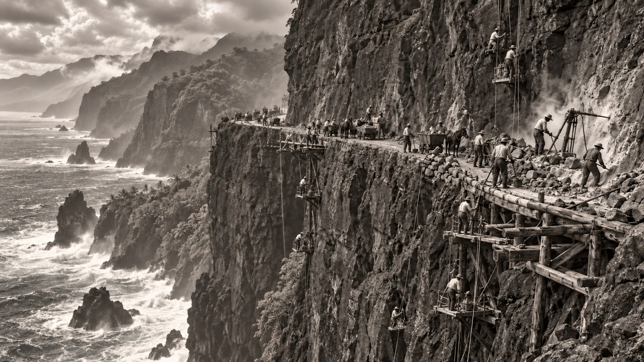
It was dense and dark and indifferent to the tools used against it. On the far side of the gorge, the trail continued. It was a horse path, barely four feet wide at its broadest, narrower still where vegetation pressed in from both sides. For generations the route had been used by Native Hawaiians moving along the coast between the settlements of Keanae, Wailua, and the town of Hana, then by plantation laborers who had no other way to reach the fields.
The trail was there. What was not there was any way to get a wagon, a loaded cart, or a piece of machinery across the forty-three ravines that sliced the coastline between the nearest junction at Haiku and the town of Hana, fifty-two miles to the east. The survey team was there to change that. The Territory of Hawaii had authorized a road—not a track, not a footpath, but a twelve-foot-wide graded and paved highway capable of carrying the automobiles that were arriving in Honolulu and beginning to reach the outer islands.
The road would open Hana to commerce. It would carry sugar cane to the mills. It would end the isolation of three thousand people who lived in the Hana district and depended on a boat service whose schedule was set by the ocean. That required building fifty-nine bridges, spanning gorges from twenty feet to more than a hundred feet deep, cut into one of the wettest and most geologically violent coastlines in the United States.
The men who built those bridges were not engineers. They were paid by the day. Most had arrived in Hawaii speaking no English; some had never seen a reinforced concrete bridge until they were asked to build one. To understand what those men did, one has to understand the northeastern shore of Maui—physically and climatically—because photographs of the finished road do not tell the whole truth.
Maui is not, in a geological sense, one island. It is two volcanoes joined by a low isthmus. The western volcano, Puʻu Kukui, is older and lower. The eastern one, Haleakala, rises to 10,023 feet, erupted within the last two hundred years, and is large enough that the whole of Manhattan Island could fit inside its crater.
The trade winds reach the northeastern flank of the mountain after traveling two thousand miles across the open Pacific, carrying every drop of moisture they gathered along the way. The mountain forces that air upward, the moisture condenses, and the rain falls. The Hana district receives between sixty-five and ninety inches of rain a year at sea level; the forests above the coast take more than two hundred inches in wet years. Some stretches of the Hana Highway receive more annual rainfall than anywhere in the continental United States.
The rain does not fall seasonally. It falls continuously, interspersed with hours or days of sun giving way to the next system moving in from the ocean. The vegetation reacts with an aggressiveness that is hard to put into words. Between the time a road-clearing crew cleaned a section of the right-of-way and the time they returned the following week, new growth was visibly claiming it back.
The forest did not wait for the work to end before taking back what had been cut. The basalt beneath that forest was another factor. Lava had flowed from Haleakala, descended the northeast slope, and reached the ocean at multiple points along the Hana coast. Since then, the sea had worked on that rock while trade-wind streams carved valleys on their way down the mountain.
The result is a coast that looks from above like a series of folds pressed into the hillside. Each fold is a valley running to the ocean, separated from the next by ridges of solid rock. Those ridges were where the road could pass; the valleys were where bridges had to be built. There was no stretch of coastline between one division and the next that did not cross at least one valley, and in many stretches three or four within a single mile.
Basalt is not a good road-building material. It is among the hardest common rocks on earth. A drill bit that lasted two months in limestone might last four days in the grade of basalt found on the Hana coast. Blasting it produces sharp-edged, irregular shards.
The fracture pattern of basalt depends on the cooling history of the original flow, and no two sections fracture the same way. A crew that learned to read the rock in one valley had to relearn it in the next, a quarter mile away. The combination of hardness, rainfall, steep terrain, and the complete absence of infrastructure meant that men who built the road to Hana were doing construction work that would have been exceptional anywhere else, and on this coast it was simply the baseline. Normal here meant that the first task every morning, before any construction began, was to inspect the previous day’s work and assess what the night’s rain had done to it.
Normal here meant planning for loss. Hana in 1910 was not a frontier settlement. It had been continuously inhabited for centuries, and the Hana district had been one of the most politically important places in Hawaiian history. Kamehameha the Great had used Maui as his base during his campaigns to unify the islands; before him, ruling chiefs had held court there.
The land the road would cross was not empty. It was dense with the remains of generations of Hawaiian settlement—fishponds, taro fields terraced into the valley floors, heiau temples on the rocky headlands, and trails that had been walked for five centuries before the first sugar plantation in the region was established in the 1860s. By 1910, the sugar industry had radically reorganized the economy and population of Maui. The main plantations in the district were owned by business interests tied to the Big Five companies that controlled most Hawaiian commerce, and operated with a largely immigrant workforce.
The Native Hawaiian population of Maui had fallen from roughly forty thousand at first European contact to fewer than eight thousand by 1900, due to diseases that arrived on ships and spread through a population without immunity. The people who worked the Hana district’s fields and lived in its camps were Filipino, Japanese, Portuguese, Chinese, and Puerto Rican, alongside the Hawaiian families who had survived. The isolation was economic as much as geographic. Hana had no land connection to the rest of Maui and no telephone line.
It depended on a boat service from Hilo on the Big Island, twenty-six miles away across the Alenuihaha Channel, one of the most dangerous crossings in the Pacific. That service ran when the weather allowed; when it did not, which was often, Hana was completely cut off. Medicine, tools, food, mail—everything that could not be grown or made locally—arrived by boat on a schedule dictated by the ocean. The town survived that way because it always had, but the sugar industry was not patient with geography.
Sugar cane moved faster overland, and the investors in Hana’s plantations wanted a road. The Board of Commissioners of Roads in Hawaii had begun planning a road to Hana in the first decade of the twentieth century. The engineering challenges were obvious from the start. The gorges required bridges.
The bridges required materials. And the materials had to reach a place no road had ever touched. The problem was logistical before it was constructional. Every nail, every bag of cement, every piece of rebar, every barrel of blasting powder had to come by boat into Hana harbor, then be moved west along the road to whatever section was under construction.
In the early years, the men building the road carried their supplies on their backs along the very trail they were trying to replace. The only way to build the road was to use the thing the road was built for. The men who built the road to Hana came from the same plantation labor force that had been reshaping Hawaii since the 1850s. During the main construction period, between 1912 and the early 1920s, they were mostly Filipino and Japanese.
Filipino workers had arrived through the contract-labor system run by the Hawaiian Sugar Planters Association since 1906. They were called sakadas, a term derived from a Tagalog word for seasonal agricultural labor, though by the time the Hana road was under construction, many of them had been in Hawaii for years and were no longer seasonal workers in any real sense. They came primarily from the Ilocos region of northwestern Luzon, a province known for producing men capable of working in conditions others would not accept. They came because recruiters told them Hawaii was a place of high wages, where a man could contribute to building something.
The wages were higher than what the fields of Ilocos paid. What they built, in many cases, was infrastructure belonging to someone else. The Japanese workers on the road crews were mostly first-generation immigrants, issei, who had arrived in Hawaii between 1885 and 1907 under labor contracts for the sugar fields. By 1914, many had completed their contracts and moved into road and construction work as free laborers, where wages were slightly better than plantation work and allowed greater freedom of movement.
They were skilled. Ten years in the cane fields had given them knowledge of Hawaii’s terrain that could be gained no other way. They knew the rain. They knew how the ground changed underfoot when the flow from the mountain rose.
They knew which stream crossings stayed passable in wet weather and which did not. That knowledge was valuable on the road crews, though it earned no extra pay. There was also prison labor. Hawaii used convict road crews throughout this period, a common practice across American territories and states.
The Maui County Jail supplied gangs that worked under guard on sections of the Hana Highway, especially in the early years when the road was being cut through the hardest terrain. The prison laborers were not paid. Territorial records described their work as a contribution to public works. The men who provided this service had no choice in the matter and no way to refuse.
Native Hawaiians worked on the road as well, though in smaller numbers than the immigrant communities. They brought what no one else could: generations of inherited knowledge of the district’s terrain. Hawaiian families in the Hana area had been crossing the valleys, stream crossings, and rocky headlands for centuries. They knew where flash floods came from and how fast they traveled.
They knew which watercourses ran year-round and which dried up in summer. They knew the old trail routes and the reasons for them, because those reasons were not random. The old trails avoided geological hazards that still existed. That knowledge, held by men classified in payroll records as unskilled laborers, was the difference between a bridge site well chosen and a bridge built directly in a flood path, doomed to wash out after two seasons.
The supervisors were territorial highway engineers, some trained at mainland institutions, most working from survey maps accurate in their broad lines but wrong in their fine details, because no map made from the sea could reflect what the terrain looked like standing on it. The division between the men holding the instruments and the men holding the drills was complete and formal, and the pay reflected it. Engineers drew monthly salaries; laborers earned daily wages. Ordinary labor on Hawaii road projects in the 1910s paid between $1.
25 and $1. 75 a day, depending on the year and location. For drilling or handling powder, the rate rose to two dollars. In today’s value, that was the equivalent of thirty-eight to sixty dollars for a ten-hour day on a volcanic cliff under a hundred and fifty inches of annual rainfall.
There was no extra pay for valley sections where the work required lowering men on ropes to drill holes in sloping walls above the stream. There was no extra pay for the bridge work where the only way to pour concrete footings was to stand in the stream itself, in water moving fast enough to knock a man down after any rainfall and carrying rocks the size of shipping crates in flood conditions. That was the wage. To understand what building a bridge on this terrain actually required, one has to set aside the postcard images.
The gorges on the Hana coast are not uniform. Each is the product of its own drainage history, its own lava flow origin, its own relationship to the moisture of the trade winds. The widest gorges are fifty to eighty feet across at road level and drop seventy to a hundred feet to the streambed. The narrow ones shrink to twenty or thirty feet in width but can be nearly vertical for their full depth.
Some are wide and deep at once; these required the longest bridges on the road, spans of a hundred feet or more above cliffs that would kill anyone who fell from them. The decision to build in reinforced concrete rather than wood was made early and was correct. Wood in the Hana rainfall does not last. The combination of moisture, heat, and the fungi that grow in both eats through timber structural elements over years rather than decades.
The bridges had to be permanent, or they would be rebuilt constantly, and the territorial budget could not support rebuilding fifty-nine bridges on any regular schedule. Reinforced concrete—steel rebar embedded in poured mix, designed to flex slightly under stress rather than crack—was the answer. The difficulty was getting the concrete to the construction site. Cement arrived by boat to Hana harbor.
Sand came from streambeds and coastal deposits along the way. The aggregate, crushed stone that makes up most of the concrete mix, came from the very basalt the crews were excavating for the road cuts. This was logistically efficient: the material they were removing from the earth became the material they used to cross it. The blasted rock was sorted by hand for aggregate size, the dust sieved out, and the usable fragments added to the mix.
The men doing the sorting were the same men who had drilled the holes and set the explosives that produced the rock in the first place. Each task fed the next in a cycle driven partly by efficiency and partly by the fact that there was no alternative. Water for the mix was never a problem; water had never been a problem on the Hana coast. The problem was keeping the mix consistent in the rain, because concrete hardens through a chemical reaction requiring a precise moisture balance, and rainfall does not respect that balance.
The crews learned to mix and pour in the intervals between storms, working fast when the weather cleared and covering the forms with whatever tarps were available when it did not. This was not engineering in any formal sense. It was adaptation born of having no other option. The footing forms for the bridges had to be built in running streams.
There was no practical way to divert most of the drainages. The water was cold, coming off the mountain, and the current in narrow valleys was fast enough in wet periods to make standing upright difficult. Men placed the footing forms in the water. They poured the forms in the water.
They drilled anchor-bolt holes for bearing plates into the rock below the surface while the stream ran at their knees, and in storm conditions past their waists. One section of the road, in an area called Wailua, passes directly over a gorge where waterfalls are visible from the bridge. The bridge spans a canyon dropping about ninety feet to the stream. The foundation on the ocean side rests on a basalt ledge fifteen feet from the cliff edge.
The men who placed that footing worked on a rock shelf that narrowed to three feet at one point, with the ocean visible directly below on one side and the deep gorge on the other. They worked there because that was where the footing had to go. No one recorded their names. The arched bridges on the road—and there are many, their concrete curves still visible from below in the old sections—required a different kind of formwork.
An arch carries its load to the abutments on either side, but to build an arch, one must first build a curved wooden frame to hold the wet concrete in place until it hardens. That frame is temporary; it carries the weight of the concrete only until the concrete sets and can support itself, then it is removed. Building arch forms in a Hana valley meant suspending a wooden frame between two basalt walls over a running stream. The form had to be rigid enough to hold the shape of the arch under the weight of wet concrete, and flexible enough to be assembled and dismantled by hand in a place machines could not reach.
The men who built the forms were carpenters the same way the men who drilled the rock were engineers—not by training or title, but by necessity and what their hands had learned through repetition. The single-lane design of most Hana Highway bridges was not an aesthetic choice. It was a practical response to the geology. A two-lane bridge requires twice the width of opening, meaning a structurally heavier bridge, deeper footings, wider abutments, and considerably more concrete.
In the valleys where the available rock for abutments was already positioned at the cliff edge, widening was impossible without blasting more rock above the road, which threatened the stability of the wall over the crews. The single-lane solution compressed the structural requirements to fit what the terrain could bear. It also meant that every vehicle crossing the Hana Highway, from its opening to today, has had to yield to oncoming traffic at each of the fifty-nine bridges. That is not a design flaw.
It is the nature of the rock. The working conditions in the Hana corridor were not a matter of sentiment but of context. The rains on Maui’s northeastern coast do not come in seasons; they come continuously and intermittently. During the main construction years, crews working the valleys between Keanae and Nahiku, the steepest and wettest sections of the road, operated under an annual rainfall exceeding a hundred and fifty inches—twelve and a half feet of rain a year, falling on men working with tools that required dry hands to grip well, concrete that required dry conditions to set properly, and explosives that required dry storage to remain reliable.
Tools corroded. Steel drill heads that would last two months in a dry climate lasted three weeks on the Hana coast. Wooden handles of sledgehammers and pry bars swelled with moisture and split. Ropes absorbed water, becoming heavy and stiff.
Blasting fuse had to be stored under temporary cover, because there was no structure on the Hana coast at that time that was absolutely weatherproof. The moisture was everywhere. It was in the rock. It ran in sheets down the faces of the cliffs the men were cutting.
It soaked into clothing that never dried between one workday and the next, and the heat compounded the humidity. The Hana coast sits at low elevation in a tropical climate. Summer working temperatures ranged from eighty to ninety degrees Fahrenheit, with humidity making it feel far hotter. A man working at full effort—drilling basalt, hauling concrete materials, carrying steel rebar down a valley slope—needed three to four gallons of water a day.
The streams supplied that water, but it had to be boiled, because the same watercourses the crews worked in were used by settlements upstream. Waterborne disease was common in the construction camps and documented in local health records as part of the operating costs of a project of this scale. The elevation changed constantly. The road to Hana rises and falls, following a coastline defined by ridges descending from the mountain and valleys cutting through them.
A workday might mean descending two hundred feet into a narrow gorge to work on footing forms, then climbing back out loaded with tools, walking half a mile to the next site, and descending again. Over a ten-hour shift on this terrain, the total change in elevation was considerable. It was never measured or recorded; it was simply what a day was. At the end of it, the men returned to camp.
The camps were canvas-roofed structures erected on whatever flat ground the terrain allowed, located near the active construction front, and moved as the front advanced. Sanitation facilities varied according to what the district provided. The food was rice, dried fish, and vegetables when available. The men who came from the sugar fields were familiar with camp conditions.
What they were not familiar with was working this far from any settlement, on slopes overlooking the ocean, with no town within a day’s walk in any direction. They were not young men, either. The common image of the immigrant laborer of that period is of a man who just arrived with nothing to lose. The payroll records of Hawaii road projects in the 1910s tell a different story.
Many of the workers were in their thirties and forties, with families in the camp or back in the Philippines or Japan, and remittances were the primary purpose of the work. These were men working to send money home. That is different from men working because there is nowhere else to go. It changes the quality of attention brought to the work.
It changes how much sacrifice they were willing to make to finish it. The fifty-nine bridges of the Hana Highway were not built all at once. They accumulated over a construction period stretching from the early 1910s to the late 1920s, with the road advancing in stages from both ends toward the middle. Some were replaced before the road was complete when the original structure proved inadequate to the rainfall.
Others were built, then damaged in floods, then rebuilt on the same footings the original crews had poured, and now stand in their third incarnation on the same ground. The bridge approaches—the built-up earth and rock that raise the road to bridge deck level—were constructed by hand using rock removed from the road cuts. Approaches are not structurally complex, but they must be built in layers, with each layer compacted before the next is added, or the soil will settle unevenly under weight and pull the pavement away from the deck. Compaction was done by hand, with a flat-faced iron tamper on a long handle, lifted and dropped repeatedly over each layer of fill.
The sound of hand tamping is monotonous. The work is monotonous. That is also why the bridge approaches in the old sections of the Hana Highway have not collapsed into the valleys below after a century of heavy rain and heavy traffic. The road cuts between bridges deserve attention, because the bridges are what visitors remember and the cuts are what made the bridges possible.
Cutting a road on the Hana Highway usually required removing eight to fifteen feet of the height of a basalt ridge to create a level twelve-foot-wide roadbed. The engineers set the survey line on foot along the ridges, using compasses and hand levels to find a center line that held a proper grade and avoided the worst geological hazards. Then the crew turned that line into rock. Drilling teams worked in the same two-man formation used in the Grand Canyon, the Royal Gorge, and every hard-rock cut in American construction history: one man held the drill, the other struck it.
In basalt, an experienced team drilled a hole roughly two and a half inches deep per hour, slower than in any standard building material except granite. The holes were then filled, tamped, and fired. The shattered rock was shoveled, hauled to the edge of the road, and thrown down the slope. Then the process repeated.
In sections where the cut required working on a face above road level, where the overhang had to be removed before work could safely proceed below, the crews drilled from the top, sometimes on ropes anchored at the summit and lowered to the right height on the face. This was done exactly as it was done in the South Kaibab Trail and at the Royal Gorge: one man on the rope, another at the anchor point. The difference on the Hana coast was what lay below. On a canyon wall, you fell into the canyon.
On the Hana coast, in sections where the road ran close to the ocean, you fell into the Pacific. There is no record of who rigged the ropes on the Hana Highway. There is no record of how many men were lowered on those ropes and how many did not come back. The construction mortality records for territorial Hawaii road projects in this period are incomplete.
The territorial government recorded deaths that required official reporting, deaths in established work camps, and deaths that necessitated notifying next of kin through the labor contractor who had hired the worker. The deaths at isolated construction sites, the deaths of workers whose families were in Ilocos Norte and had no address in territorial records, and the deaths that happened and were buried and then forgotten—these appear in no document that survives. What survives is the road. The Hana Highway was never completed permanently.
It was finished the way all construction in the Hana corridor is finished: temporarily, with the understanding that the weather would undo it. Flash floods in the Hana corridor arrive faster than floods on any major watercourse because the watersheds on the slopes of Haleakala are steep enough to turn rainfall into surface runoff in minutes rather than hours. A storm dropping two inches of rain on the summit sends a flood wave into every northeastern stream within thirty minutes. Streams ankle-deep in dry weather become waist-deep and moving at fifteen miles an hour in flood; streams waist-deep become impassable.
The streams do not distinguish between the road that took six weeks to build and the vegetation that stood there for a thousand years before it. In 1932, a single flood damaged eleven separate bridge approaches on the Hana Highway and washed out two full sections of road in the Keanae drainage. The repair crews that worked that summer rebuilt the fill approaches and realigned sections of the road using the same tools and methods the original construction crews had used twenty years earlier. Some of them were the same men.
The Filipino and Japanese workers who built the road in the 1920s were still in the Hana district in the 1930s, older, still classified as laborers on government payrolls. Some brought their sons. The pattern repeated over the following decades. The 1946 tsunami caused damage along the Hana coast, requiring reconstruction of sections near the water.
Hurricane Iwa in 1982 closed sections of the highway for weeks. Each reconstruction added a new layer of work to the same ground the original crews had cleared decades before. The road requires yearly maintenance. The state has employed road maintenance crews in the Hana district continuously since the road was completed.
The names of the current maintenance workers appear on no plaque. The Hana Highway today receives about one and a half million visitors a year, making it one of the most-traveled scenic roads in the United States. It is not a highway by any modern standard. It is narrow, winding, and slow, requiring four to five hours of continuous careful driving to complete.
Rental car companies on Maui issue warnings. The bridges carry weight-limit signs. There are stretches where two cars cannot pass at once and one must back up to a wider spot. Tourists driving the road photograph the waterfalls.
They stop at the black-sand beach at Waianapanapa State Park. They park at Kipahulu Peninsula and look out over taro fields still cultivated by Hawaiian families on the same land their ancestors worked. They eat at roadside stands in Hana, then head south to the pools of Oheʻo Gulch. They call it beautiful.
Few of them stop at a bridge. That is not a criticism. The bridges are not marked as historic landmarks; they do not announce themselves. They are simply there, as they have been for a hundred years, carrying the road across the same watercourses they were designed to cross in the 1920s.
Some have been widened. Some have been replaced. A number of the original narrow-span concrete arch bridges remain in service. Their arches can be seen from below by anyone who knows how to look.
The men who poured those arches are gone. The Filipino drillers who cut the basalt in the Kanaʻio section are gone. The Japanese men who placed the footings in the Nahiku streams are gone. The Native Hawaiian men who guided the survey crews across terrain their families had walked for centuries are gone.
The prison laborers who worked the earliest sections of the road without pay and without choice are gone. Their names do not appear on any memorial plaque along the highway. There is a particular quality to the forgetting that surrounds the Hana Highway, distinct from the forgetting at the Grand Canyon or the Royal Gorge. In those places, the workers were forgotten because the records did not mention them.
In Hawaii, there is another dimension. The Filipino and Japanese workers who built the Hana Highway were immigrants in a territory that did not consider them potential citizens. The Naturalization Act of 1790, as amended and interpreted into the early twentieth century, restricted naturalization to whites and, after 1870, to persons of African descent. A Filipino man who had lived in Hawaii for twenty years, built the road, and raised children in the territory could not become an American citizen.
His labor was essential to the project, but he had no standing in its records. Government construction documents reflect this in the classification used for the Hana Highway workforce: foreigners, not workers. Foreigners. The word classified them by their exclusion, not their contribution.
The exclusion was official, legal, and enforced. The contribution is structural and permanent, driven over by a million and a half people every year, who describe the journey as one of the most beautiful experiences of their lives. The engineers who designed the Hana Highway worked from maps showing a line from Haiku to Hana. The line was correct in theory; it connected two points.
But what it crossed was not merely a line. It crossed forty-three valleys with near-vertical basalt walls. It crossed stream courses that could flood within thirty minutes without warning. It crossed a coastline receiving more annual rainfall than any road project in mainland American history was ever asked to withstand.
The engineers drew the line. The men who drilled the rock, set the forms, and poured the concrete into running streams are the ones who cut the road. Every deviation from the survey line is a decision made by a man on a cliff, using a pry bar, looking out at the ocean, with no option to turn back and consult a supervisor. Every bridge that crosses a valley at an angle rather than a straight line is the product of one man’s reading of the terrain, his understanding of what the rock would bear, and his adjustment of the course.
Every arch that still holds its curve after a century of tropical rain is the product of understanding gained not from drawings but from the experience of a man who came before him in the work, who knew how long the concrete had to be left before the forms could be stripped. The bridges still stand. The concrete is still sound. The arches are still true.
If you drive the Hana Highway today, stop at one of the old single-lane bridges, get out, walk to the railing, and look down at the stream, you are standing on the work of men whose names appear in no document. The water running over the basalt below you is the same water those men worked in when they set the footings. The basalt is the same. The arch above that water was poured by their hands on a day when nothing was recorded.
Put your hand on the railing. Someone stood where you are standing now. They looked at the same stream. They poured the railing cap and walked back to camp, ate rice from a metal plate, and came back the next morning.
They built this in rain that did not stop, on rock that did not yield, for wages that accounted for neither. Tourists still cross. The stream still rises. And somewhere in the archives in Honolulu, on a page of accounts recording only the contract amount and the completion date, lies the only official trace of the summer those men spent in that valley, above that water, under that rain.
That is what it means to build a road that a million and a half people cross every year and call beautiful, without ever once looking at the hands that made it possible.
