On August 21st, 1916, about a thousand people climbed into the San Juan Mountains of Colorado to celebrate a new road over Wolf Creek Pass, 10,857 feet above the sea. What they had come to see was a dirt shelf twelve feet wide. Work crews had blasted it out of the mountainside with dynamite and cleared it with hand tools, and it clung to the rock above the valley of Wolf Creek, curving around the cliffs and out of sight toward the Continental Divide. But a few weeks earlier, the first cars to try that shelf had come within inches of going over the edge.
The state highway commission’s records, a Denver newspaper report from the job, and a typed account by one of those first drivers tell how that shelf got onto the divide. Two threads run through them. One belongs to the engineers and county men who pushed a road over a pass the pioneers had never thought worth a road. The other belongs to a Pagosa Springs mother named Myrtle Hirsch, who watched the new road give way under her own car.
By the end, you will know how a twelve-foot shelf was cut over the Continental Divide in two working seasons, who paid for it, and why its first drivers had to be lined up by an engineer before they were allowed to roll. In July of 1910, three men from Colorado’s brand new state highway commission were driving the western slope to see what roads the state actually had. They were its chairman, C. P.
Allen of Denver, Thomas Tully of Durango, and the commission’s engineer, J. Maloney. From Pagosa Springs, they turned east up the east fork of the San Juan River on the only road that crossed the mountains there. That road climbed to a summit called Elwood Pass.
First, though, it climbed a grade called Timber Hill, and Timber Hill stopped them cold. The three men had to put up for the night at the bottom of it. The next morning, they hired a span of mules to help them over the top. Maloney wrote later that the stretch from the East Fork to Elwood Pass had a great many very steep grades, and Timber Hill was the worst.
So, the men in charge of Colorado’s highways needed mules to get over Colorado’s highway. That road was already old. The army had laid it out in the late 1870s to supply a new post called Fort Lewis at Pagosa Springs, running from Fort Garland in the San Luis Valley. Its first winter beat the army so badly that the soldiers sent their supplies over a pass farther south.
In 1879, a Silverton newspaper complained that a $5,000 federal appropriation for the road was used up and the road was still twenty-seven miles from open. The state took it over anyway, and for more than thirty years, Elwood Pass was the way into Pagosa country from the east. Then, in early October of 1911, those mountains got the worst flood on record. The East Fork came roaring down its canyon and took the road with it from the base of Timber Hill all the way down to where the two forks of the San Juan meet.
The southwest corner of Colorado had lost its road to the east, and the obvious fix turned out to be the one nobody could agree on. The state’s first idea was simple: rebuild Elwood. But that plan ran straight into the towns on the far side of the mountains. Monte Vista, Del Norte, and South Fork sat on the Rio Grande side of the divide, and the old Elwood Road went around all three of them.
Rebuild it, and every tourist bound for the San Juan Basin would keep missing their main streets entirely. Down in the southwest, a Durango man named Herr, who sat on the state’s highway advisory board, worked alongside a state senator named West to push just as hard for an outlet to the east. Everybody wanted a road. They just didn’t want the same road.
What came out of that fight was a change of a few words on paper. The state highway had been designated up the East Fork to Elwood Pass. It was redrawn to run up the West Fork of the San Juan, up Wolf Creek to the top of the divide, and down the other side to meet the Alamosa-to-Creede road at South Fork. That one change moved the state highway onto a brand new line over the mountains.
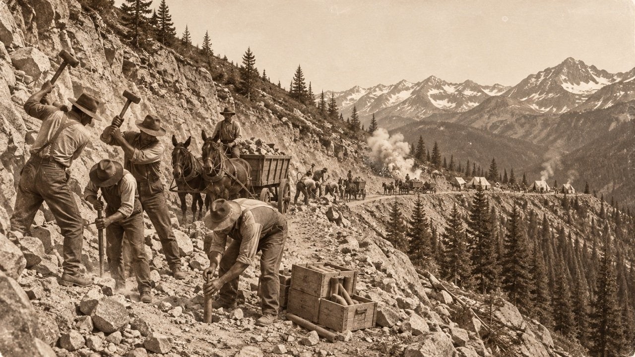
So, how do you put a road where there isn’t one, in 1914, at more than 10,000 feet? The work was let out in contracts a mile at a time, and the engineers assigned to the project were Maloney and a second man named Ed Riley. Nearly all of it was done with hand tools. The rock was broken loose with dynamite, and then the crews moved the broken pieces off the line and packed what was left into a roadbed where the slope fell away too steeply to hold a bench of dirt.
A rock wall was built up underneath to carry the road. Repeat that across the face of a mountain: blast and clear and pack and wall. And what you end up with is a shelf. Twelve feet of it was the whole road for traffic going both ways.
The people doing this work lived up there. Construction crews camped on the west side of the pass with their families. A photograph of one of those camps shows cases of dynamite piled out in the open near the cook fires. In the fall of 1915, a Denver newspaper writer came out to see how the job was going.
On October 22nd, he reported that the new road was forty-four miles long. It would cost more than $76,000, and $16,000 of that was for the last link still underway. It was passable now, he wrote, though not for the average motorist. A stockman and banker named Fred Catchpole, a county commissioner from Archuleta County, had just made the first trip over it in an automobile.
And the writer added something that explains exactly why the San Juan towns wanted this road so badly. There were prosperous people in that corner of the state, he said, who had never bought an automobile at all because it was too hard to get out to the east and the north. That’s a remarkable line to find in a road story. People who could afford a car didn’t own one because there was nowhere to drive it.
By that fall, the shelf was nearly done. The crews had about ten days of work left when a winter storm rolled into the San Juan Mountains. That storm shut the job down for the season, and the nearly finished shelf sat buried in snow on the divide all winter, which left the towns that had been paying for it waiting another year for their road. And they really were paying for it.
The money behind Wolf Creek Pass came from a list that reads like a roll call of the San Juan country. The Del Norte Commercial Club put money in. So did the town of Del Norte and the town of Pagosa Springs, Rio Grande County and Archuleta County, the state of Colorado, the United States Forest Service, and the federal government. A newspaper in Alamosa put the cost at roughly $5,000 a mile.
That’s the same $5,000 the government had spent back in 1879 on the entire Elwood Road, the one that ended up twenty-seven miles short of open. Now, that much money was going into a single mile. The state’s share came out of a system that was still very young. Colorado’s legislature passed its highway commission law in 1909, and the three commissioners took office on the first day of 1910.
In 1913, the state started paying for its roads with vehicle registration fees. So, every car in Colorado was helping to build the roads it needed. By 1915, there were 5,844 miles of designated state highway on the books. Designated meant a line on a map, and on a lot of those miles, a car still fought the ground.
Meanwhile, the people of Pagosa country still had to get in and out somehow. For almost five years, anyone heading for Pagosa Springs by the old route turned off before an old homestead called Joe Mann’s Cabin, climbed a rocky trail to Windy Pass, and came down the other side to the West Fork. A rocky trail stood in for a state highway. So, where did a three-man commission and a handful of mountain towns get the idea that a road over the Continental Divide was something a government should build at all?
The answer goes back to the bicycle. In the 1890s, the loudest voices in America asking for better roads belonged to cyclists. The League of American Wheelmen and bicycle makers led by Colonel Albert Pope pushed for road laws in Washington, in the state capitals, and in the counties. They called it the good roads movement.
On March 3rd, 1893, Congress approved a small office of road inquiry inside the Department of Agriculture, and a Civil War general and engineer named Roy Stone was put in charge of it. In 1905, it became the Office of Public Roads under Logan Waller Page. That same year, a Colorado Good Roads Association formed in Denver. Then, on July 11th, 1916, while the crews on Wolf Creek were still breaking rock, President Woodrow Wilson signed the Federal Aid Road Act.
It was the first federal highway funding law in the country. It promised $75 million over five years. Every federal dollar had to be matched by a state dollar, and the money flowed only through state highway departments. Colorado reorganized the very next year, creating a state highway department and a state highway fund to handle state and federal money together.
Look at the timing. Wolf Creek Pass was paid for mostly the old way, a share at a time, from the towns and counties that wanted it. The law that would change how roads like it got paid for arrived just six weeks before this one opened. But the shelf still had to be finished, and its first drivers went over it weeks before any ceremony.
In February of 1916, Pagosa Springs was snowed in. So the Hirsch family shipped their Chalmers motor car out on the Denver and Rio Grande narrow gauge railroad to Santa Fe, New Mexico. From there, Myrtle Hirsch, her husband David, their thirteen-year-old son Joseph, and their small daughter Marguerite went touring through warmer country, about six thousand miles of it. They planned to come home that summer over the new pass from the east side.
In Denver, they bought a second car, a new seven-passenger Cadillac with a V8 engine. In July, they reached the Decker Creek work camp high on the mountainside and found Myrtle’s sister there with her two teenage sons, Eugene and George Hatcher, also waiting to cross. The highway engineer told them it would be a few more days. Heavy rock work had slowed the crews down.
Myrtle wrote about good fishing, cold mountain water, and big spruce trees. On July 26th, a messenger came. The engineer would arrive at ten the next morning to line the cars up. Everyone was to put their car tops down because rocks still stuck out over the road.
That night, it poured. In the morning, the engineer set the order himself. A couple in a Ford roadster went first, then the Goodnights of Monte Vista in a Buick, then the Hatchers in a Reo, and the Chalmers and the Cadillac last, because, in his words, the heavier cars might mess up the road for the others. An engineer had to decide which cars went first so the road would survive them.
Myrtle and David had walked that grade while they waited. Even dry, she wrote, it was only a few inches wider than the camp wagon tracks, with a wall of rock on one side and straight down on the other. The engineer told them it was well packed. He also told them not to drive too close together.
They rolled out under heavy cloud. Myrtle wrote that they felt they were making history: the first group of cars over the hill. Nearly a mile from camp, on the steepest pitch, in mud she called slick as soap, the Ford stopped. Up ahead, face to face with the Ford, was a wagon train.
There were three big loaded covered wagons with extra horses behind each one, and a crowd of people who had been camped at the west foot of the pass for three weeks waiting to cross. The engineer had told them to wait for his clearance, because on that shelf, two outfits could only pass each other in a few places. Their leader had run out of patience. He climbed down wearing a revolver and ordered every car to back up the mountain until his wagons could get by.
How that standoff ended sits in a part of Myrtle’s account that isn’t in print today. The next pages pick up that night. Myrtle reached the next work camp so worn out that the cook and his helper moved their beds into the dining tent to give her a place to lie down, and the rest of her family didn’t roll in until eight o’clock. The next morning, the sun came out.
A man named Logan sent a crew ahead early to fill a hundred-foot bog with spruce boughs. And even then, every car had to be pulled through it. They made the top of the pass. They were told the troubles were over, because it was all downgrade on road packed the fall before.
Joseph and Myrtle brought the Cadillac down last at ten miles an hour in low gear. They came to a section of road that sat on a built-up rock wall. The tracks of the cars ahead ran just four or five inches from its edge, and it looked safe enough. Then the whole wall gave way.
The left side of the Cadillac dropped and hung out over the drop. Myrtle wrote that only a very small rock under the left front wheel kept them from going down. Myrtle and Joseph slid out on the uphill side as carefully as they could, and the big car rocked as if it were already on its way down. One puff of wind, she wrote, seemed enough to send it.
They stood on the shelf and looked around. Every other car had gone on ahead, and they were alone, miles from any work camp. After fifteen or twenty minutes, a wagon came along carrying two men, a load of heavy cables, and a bicycle. The men tied the Cadillac to the trees on the uphill side with ropes.
For a while, then, a brand new Cadillac sat on the Continental Divide, held up by a few ropes and one small rock. Then one of them got on the bicycle and rode it two miles down the new road, where he met David walking back up with some of the work crew. What happened next was the same kind of work that built the road, done for one car. The crew cut down several small trees and built cribbing, a frame of logs laid crosswise like the corner of a log cabin, filled with rocks so it can carry weight.
They set it under the hanging side of the car. Then they jacked the car up a little, built the crib higher, jacked again, and kept going until the Cadillac sat nearly level on a platform of logs and stone where the rock wall had been. Six men held the cables while David drove it onto solid ground. The nearest tree that could have stopped the car if it had rolled was forty feet down the slope.
While the men worked, Myrtle carried drinking water up the bank from the creek in a pint cup, because by then it was midday in a July sun. When the job was nearly done, she took photographs. One of the pictures of their car leaning out over that mountainside still turns up in the Pagosa Springs newspaper’s history column. Two miles down, little Marguerite had been waiting alone for all those hours with no idea what had happened to anyone.
The family was together again, and nobody was hurt. Then the fear caught up with Myrtle. She started shaking and couldn’t stop, and she kept getting weaker as the miles went by. Within two miles of Pagosa Springs, at the Todd Ranch, she fainted.
They laid her on the grass beside the road and brought her around with water and spirits of ammonia. Decades later, writing all of it down, Myrtle said she still loved Wolf Creek Pass with its forty-seven years of memories. The shelf had nearly taken her car and her son, and she still called it “our Wolf Creek Pass. ”
Three weeks after that crossing, the state was ready to throw its party, and it didn’t hold it on the summit.
The official opening of Wolf Creek Pass came on August 21st, 1916. The plan was to hold the ceremonies right on top of the pass. Instead, they were moved to the head of the Box Canyon, twelve miles to the east. And the record doesn’t say why.
Government officials came. So did 250 automobiles. The crowd was served free elk meat and coffee. Pagosa Springs old-timers had a story about that elk meat, and it’s worth hearing as exactly what it is: a story.
At historical society meetings in the 1970s, they liked to say that a famous local hunter named Buck O’Neal had mixed buzzard meat in with the elk. Nobody ever proved it, and the people telling it laughed every time. The bill was real enough. The Denver writer in 1915 had guessed $76,000.
When the work was done, the pass had taken two years and about $100,000, roughly a third more than the estimate. That was the price of forty-four miles of shelf over the divide, paid for by commercial clubs and county commissioners. And the road’s own clock kept running from that day. Between 1922 and 1924, crews widened parts of it to twenty feet.
When the federal government numbered the country’s highways in late 1926, the pass first carried US 450. In 1930, it was widened to twenty-four feet, twice the shelf that opened in 1916. In 1934, it became US 160, the number it still carries. In January of 1937, the State Highway Department sent a rotary snowplow up to the pass to try to keep it open all winter, and that winter it stayed open except for a day or two at a time during storms.
In 1950, thirty-four years after the opening, it was finally paved. The Durango Herald would later call it the state’s number one dangerous pass. And in the middle 1970s, a country singer named C. W.
McCall recorded a song called “Wolf Creek Pass” about a truck losing its load on the way down. So, what is left of that shelf today? Start at South Fork on the Rio Grande side, where the old fight over the route ended, and drive west up US 160. On the east side, the highway passes the place called the Alberta Slide, where a snowshed was planned for the winter of 1964.
The Durango Herald reported it would be the first shed of its kind on a Colorado highway. Farther up, the road runs through a tunnel 900 feet long that opened on November 5th, 2005, to keep falling rock off the highway. At the top, 10,857 feet up, the summit sign marks the Continental Divide. Close by, a ditch called the Treasure Pass diversion carries about 125 acre-feet of water a year from the western slope over the divide to irrigate the San Luis Valley, and a measuring flume near the summit counts it.
The Continental Divide Trail crosses here too, and northbound hikers usually reach the pass in June. The pass averages around 392 inches of snow a year, so if you’ve crossed it in winter, you’ve driven between walls of it. Just east of the summit, the Wolf Creek ski area sits beside the highway, and a Denver Public Library photograph from February of 1950 shows its rope tow running next to a plowed US 160. On the north side, a side road climbs to Lobo overlook at 11,760 feet, high enough to look down on the whole line of the road.
Then start down the west side, the side where the Hirsch Cadillac hung over the edge. The grade runs as steep as 6. 8 percent, and two runaway truck ramps wait for anyone whose brakes give out. Partway down, the Wolf Creek Pass overlook sits right on the sharpest hairpin of the climb up from the west.
Farther on, Treasure Falls pours down beside the highway. Below it, the road reaches the West Fork of the San Juan and follows the river toward Pagosa Springs. Before town, near the second bridge over the San Juan, a Forest Service road turns off up the East Fork. That’s the old Elwood route, the road the flood took in 1911.
Some of the old buildings that belong to Joe Mann still stand above the East Fork, much changed. The paper trail survives, too. The state highway commission’s biennial reports for 1914 and 1916, with the construction story and the expenses, are held by the Colorado State Publications Library. That August, the San Juan Prospector and the Alamosa Journal carried the opening, and both papers are in the Colorado Historic Newspapers collection.
The Center of Southwest Studies at Fort Lewis College in Durango keeps old postcards of the pass, and Myrtle Hirsch’s typed account came down through Marguerite, who later handed a copy to the Pagosa Springs historian John M. , who printed it. Picture that opening day crowd one more time, standing beside a twelve-foot shelf of dirt and blasted rock. Two summers earlier, there had been no road over that mountain at all.
Every mile under their feet had been paid for by towns, counties, the state, and the Forest Service, cut with hand tools and dynamite, and walled up with stone. A few weeks earlier, one of those walls had let go, and a family’s Cadillac had hung over the edge until men with logs and cables gave the road back. That’s how America cut a road over Wolf Creek Pass.
It took a flood, a fight between towns, and two summers of dynamite and shovels.