The drill team went back over the edge of the cliff at dawn. One man lowered himself on a rope scaffold against the granite face, pressed his boots into the rock, and held the steel. The second man, above him on the ledge, swung the hammer. The steel bit in an inch at a time.
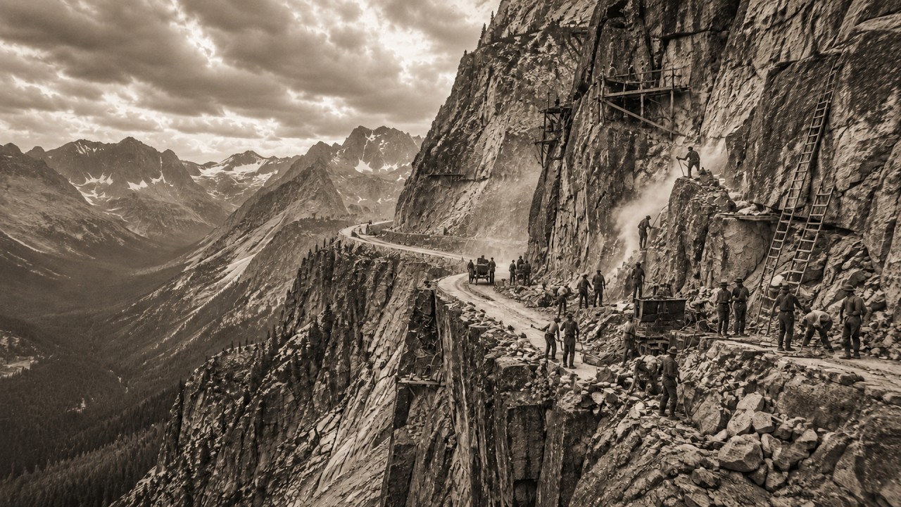
The hole had to be three inches in diameter and as much as four feet deep before the powder gang could load it with dynamite and fire the round. Each hole took hours. Each round of holes took a full shift. When the blast cracked the rock, the mucking crew cleared what fell, loaded the broken granite into dump trucks where trucks could reach, and carried it in wheelbarrows where they couldn’t.
Then the rope went back over the edge and the drilling started again. This was June 1931. A road crew had assembled at the base of a cliff in Carbon County, Montana, unloaded their tools from a convoy of trucks that had come as far as trucks could go, and looked at what they had been hired to cross. The cliff rose 1,600 feet from the floor of the Rock Creek Valley in a series of granite steps that no road had ever climbed.
Above it, the Beartooth Plateau stretched southwest toward Wyoming: a high, flat expanse of exposed rock and ice above 10,000 feet, treeless and windswept, buried under thirty feet of snow for eight months of the year. At its highest point, the ground reached 10,947 feet above sea level. That was the summit. That was where the road was supposed to go.
No paved highway in the lower forty-eight states had ever been built that high. No road crew had ever tried to lay and hold a surface across terrain that stayed frozen into July, where the alpine soil was too shallow to anchor a culvert, where the wind could blow a loaded truck off a ledge, and where the nearest supply town, Red Lodge, Montana, sat seven miles and 5,000 vertical feet below. The men who climbed out of those trucks were not the men who had designed the road. The designers had come the previous summer with transits and measuring chains and had returned to their offices to produce blueprints.
The men who climbed out in June were there to do what the blueprints described: cut a two-lane highway across a cliff face and a plateau that had never been touched by a graded road in all of human history. To understand why anyone thought this was worth attempting, and why the federal government agreed to fund it, you have to understand what Red Lodge, Montana, was by 1929. It was a coal mining town on the wrong side of a mountain. The coal seam that had built it in the 1880s was thinning.
The miners who had come from Finland and Scotland and the Austro-Hungarian Empire and Italy were watching their livelihoods diminish at the same moment the entire American economy was beginning to collapse. The town’s boosters understood that if Red Lodge was going to survive the death of its coal industry, it needed something else. What it had just past the cliff at the end of the Rock Creek Valley was the northeast entrance to Yellowstone National Park. Yellowstone was already drawing tourists from across the country.
But to reach the park’s northeast gate from Red Lodge, a traveler in 1929 had to drive one hundred miles north, west, and south around the Beartooth Range. The cliff at the end of Rock Creek was only seven miles from Red Lodge. If a road could cross it, the detour became a direct route. A local physician, Dr.
John Siegfried, had been arguing for the road since the early 1920s. He took surveyors into the mountains. He wrote letters to the state highway department and to the Bureau of Public Roads in Washington. He brought politicians to the base of the cliff and pointed up.
It took nearly a decade of this before anyone with the authority to act agreed that the road was possible. In 1929, the Bureau of Public Roads sent its own survey team to assess the route. Their conclusion: the road could be built. It would cost approximately $2.
5 million. It would require the most technically demanding highway construction the bureau had undertaken in the continental United States, and it would need to be done in short construction seasons. The plateau was accessible to work crews only between roughly June and September, which meant each year’s work had to be completed, consolidated, and secured against winter before the snow returned in October. Construction began in the summer of 1931.
The crews were drawn from Montana and Wyoming, men who had worked in the region’s mines and on its railroads and farms, most of them out of regular work by the time the depression arrived. Wages for common labor ran four dollars a day. Skilled work—drilling, blasting, equipment operation—paid somewhat more, up to six or seven dollars for a man the foremen trusted. In today’s money, that is seventy-five to one hundred and thirty dollars for ten hours of work at 10,000 feet of elevation, in weather that changed from clear to violent in the time it took to eat lunch.
There was no overtime. There was no hazard pay. The men were expected to be at the workface at the start of the shift and to keep working until the shift ended, regardless of what the weather had decided to do. The first problem was the cliff.
From Red Lodge, the highway needed to gain approximately 5,400 feet of elevation in roughly twelve miles, at a grade manageable by the vehicles of the early 1930s. The maximum sustained slope was around six percent. To gain 5,400 feet at a six percent grade required about seventeen miles of road. You cannot fit seventeen miles of road into twelve miles of horizontal distance without switchbacks.
The engineers designed twenty-nine of them on the Montana face alone—reversals that would allow the road to gain elevation by changing direction repeatedly, each turn adding vertical progress while limiting the grade on any individual stretch. On paper, the switchbacks were logical. On the ground, each one required cutting a flat platform wide enough for a fully loaded truck to reverse course, into a cliff face that gave the construction crews nowhere to stand while they did it. The drilling began at the base of the lower switchbacks in early June and worked upward.
The technique was the same that had built every other road through hard rock in the American West: two-man drill teams, one holding the steel, one swinging the hammer. By 1931, black powder had been largely replaced on road projects by commercial dynamite, which was more predictable and could be handled more safely. The blasting gang cleared what the explosion left. Then the drill teams went back to work on the freshly exposed surface.
The cliff face on the lower Montana approach is not one uninterrupted wall. It is a series of ledges and steps, each presenting a different angle, a different rock type, a different set of fracture patterns that determined how the blast would break and how the rubble would fall. An experienced driller read these fracture patterns before he placed his holes. A hole drilled into the wrong orientation on a fractured ledge could produce a blast that threw debris outward rather than downward, sending shards of granite across the workface at velocity.
The construction records note several injuries from exactly this type of misfired blast. They record the injuries in the passive voice—a worker was struck, injuries were sustained—and they do not always record names. At the switchback platforms, the engineering problem was stability. A switchback is not simply a turn in the road.
It is a horizontal platform cantilevered from a cliff face, held in place partly by the material below it and partly by the material behind it. On a granite cliff, the material below and behind a freshly blasted platform is broken rock and debris that has not yet settled. A platform built on uncompacted blast rubble will shift as the rubble compresses, pulling the road downward at the outer edge. The road builders solved this by constructing retaining walls of dry-stacked native stone at the outer edges of each platform, packing the interior with compacted gravel and road base, and allowing the first winter’s freeze-thaw cycle to settle the material before paving over it.
This meant that sections of the road could not be paved until the second summer after their excavation. The construction moved in phases, and the phases overlapped. On some sections, blast crews were working above a surface that was being paved below, while finished crews laid stone walls on platforms still being drilled from above. The two most famous switchbacks on the highway are the pair known as the Mae West Curves.
They sit near the top of the Montana face, where the road makes two consecutive reversals in a configuration that, seen from above, resembles the silhouette of a woman’s figure. The name came from the workers, and it stuck. What the name does not capture is what the curves required at the time of construction. The granite at this section is heavily fractured along natural joint planes running approximately perpendicular to the road alignment.
Blasting along these joint planes tended to produce large unstable blocks rather than small, manageable rubble. The retaining walls at the outer edges of these platforms were built with exceptional care, because the material behind them was inherently mobile. Several sections of the original stonework were rebuilt in the 1940s and again in the 1960s. Some of the original walls are still in place.
The plateau itself presented a different set of problems. Once the road reached the top of the cliff, the crew was no longer fighting vertical rock. They were fighting horizontal distance across terrain that looked, to anyone accustomed to lower elevations, like it should be easy. It was not easy.
The Beartooth Plateau is not a flat surface. It is a series of glacially scoured basins and low ridges covered with a thin layer of alpine soil sitting on top of granite bedrock anywhere from a few inches to a few feet below the surface. In the high basins, the soil stays saturated through most of the construction season because snowmelt has nowhere to drain. A road crew trying to grade a road across a saturated alpine basin in July is working with material that behaves like wet concrete when loaded and like soup when disturbed.
You cannot compact it. You cannot drain it without culverts, and installing culverts requires excavating below the water table in material that refills the excavation as fast as it is dug. The engineers designed a system of rock-filled drainage trenches running perpendicular to the road alignment, allowing the saturated soil to drain laterally away from the road base. Where the soil was too waterlogged to support any road base at all, they went deeper and replaced the organic material entirely with compacted gravel hauled from the valley below.
Hauling gravel to the plateau was its own problem. The trucks that could navigate the unfinished switchbacks were not always the trucks that could carry the volume of material the plateau work required. The construction crews operated a mix of equipment: early-1930s dump trucks on the lower switchbacks, horse-drawn graders on the plateau surface where the ground was too soft for wheels, and hand labor everywhere that neither trucks nor horses could reach. There are photographs from the 1932 construction season showing work crews on the plateau using horse-drawn Fresno scrapers to move road base across sections that look, in the images, like they should be easy driving.
In the photographs, the horses are up to their fetlocks in the alpine soil. To work a construction season on the Beartooth Plateau meant this: the crew was housed in a base camp in Red Lodge and transported by truck to the workface each morning. The ride from Red Lodge to the active construction zone in 1932 and 1933, when the lower switchbacks were complete but the upper road was still being cut, took most of an hour each way on a surface that was under active construction. The men arrived at the workface already strained from the ride and the altitude.
Working above 10,000 feet produces standard symptoms even in healthy men: reduced endurance, persistent headaches, shortness of breath under exertion. A man swinging a sledgehammer or pushing a loaded wheelbarrow at 10,500 feet has roughly thirty percent less oxygen available with each breath than he would at sea level. The work was the same. The oxygen was not.
The weather on the plateau could change in under an hour. A clear morning at the workface could become, by ten o’clock, a full alpine thunderstorm with lightning striking the open plateau and hail that stripped exposed skin. In these conditions there was no shelter on the workface. The men got wet and waited, or they rode back down.
Either way, the day’s progress stopped. A construction season on the Beartooth had perhaps ninety to one hundred workable days. Ten storm days is a ten percent reduction in available work time. And the work that remains does not get easier.
In June of 1933, the Civilian Conservation Corps established camps in the Red Lodge area and sent crews to assist with the highway. The CCC boys worked alongside experienced road-building crews who had been on the job since 1931. The dynamic was the same as it had been on the Grand Canyon trails a few years earlier: young men from cities and Midwestern farms who had never worked in high-altitude terrain, learning the work from older men who had spent years doing it. The CCC workers on the Beartooth earned thirty dollars a month, of which twenty-five dollars went directly to their families.
They kept five, at ten hours a day and six days a week. That is approximately nineteen cents per hour—in today’s money, roughly four dollars an hour for work at 10,500 feet, in weather that included afternoon thunderstorms in summer and snow in both June and September, doing work that included blasting, stone setting, and hauling fill by hand across terrain the trucks could not reach. The most dangerous single section of the construction was a stretch of the upper Montana face where the road alignment crossed two remnant snowfields that persisted through the entire construction season. These were not patches of late snow.
They were compacted glacial features: layers of ice covered by a shallow skin of summer melt that the sun could not reach long enough to clear. The road had to cross them directly. The engineers considered routing around them and rejected it. Adding the necessary distance would have pushed the grade beyond what vehicles of the era could handle on the descent.
So they went through. The crews spent most of the 1933 and 1934 seasons cutting into the ice and filling the excavations with blasted granite from adjacent cliff sections. The fill settled differently than the surrounding soil. It still does.
On a warm September day, if you drive the upper switchbacks and watch the pavement carefully, you can see where those old snowfields were. The road surface sits slightly lower at those points—gentle depressions that have been compacting for ninety years. The highway was completed in the summer of 1936. The formal opening took place on June 14th of that year.
President Franklin D. Roosevelt attended. There were speeches. There were photographs.
The photographs show Roosevelt in the back seat of an open car on a section of the newly paved road, the cliff face on one side and the valley dropping away on the other. He appears to be enjoying the view. The view is, by any standard, extraordinary. The men who built the road are not in the photographs from the opening ceremony.
They were not invited. The Bureau of Public Roads construction records from the Beartooth Highway project survive in archival collections. They are thorough in the ways official records of this era are always thorough: costs, material volumes, equipment hours, completion dates for each section. The names of the project engineers are in the records.
The names of the foremen appear in many places. The names of the men who held the drills and swung the hammers and set the stone retaining walls at the switchback platforms appear occasionally in payroll ledgers that list them under job classifications—driller, laborer, mucker. Some men appear for a few weeks and then vanish from the ledgers without explanation. The records do not say where they went.
A switchback platform on the Beartooth is wide enough for a truck to make a full reversal. At the outer edge, the cliff drops away. At the inner edge, the cliff continues upward. The platform is, in its simplest description, a shelf blasted out of a vertical rock face.
To blast a shelf, you first have to stand on the rock face while you drill. On the lower switchbacks, where the cliff is steep enough that there is no natural ledge to stand on, the drilling crews worked from rope scaffolds—the same system used at the Royal Gorge, the same system used at the Grand Canyon. One man on a rope pressed against the granite. Another man above him operating the winch.
The hole went in an inch at a time. The powder went in when the hole was deep enough. The blast cracked the rock. The mucking crew cleared what fell.
Then the rope went back over the edge and the drilling started again. The outer retaining walls of the Beartooth switchback platforms were built using the same dry-stack technique the Hermit Trail crews had used in the Grand Canyon two decades earlier: native stone selected from the blast rubble, fitted by hand against adjacent stones. No mortar. The geometry of the wall providing its own strength.
A dry-stack wall on a cliff edge is not a decoration. It is the only thing between the road surface and the drop. On the Mae West Curves, the original retaining walls were built from granite blocks averaging between eighty and two hundred pounds each. Each block was carried or rolled to its position by hand.
The wall face is plumbed to within fractions of an inch over distances of thirty and forty feet. This is not accidental. It is the result of a man’s eye and a man’s hands and a man’s knowledge of how stone transfers load, developed over years of doing this work in places where being wrong meant not going home. When the first winter came after the 1931 season, the crews returned in June of 1932 to find sections of retaining wall displaced by the freeze-thaw cycle, road-base material shifted by ice heave, and culverts pushed partially out of their beds by frost.
They repaired what had moved and continued upward. This happened at the end of every construction season for five years. The plateau is still doing it. The Montana Department of Transportation has a spring inspection protocol for the Beartooth Highway that looks for exactly the same failures the original crews repaired in the 1930s: frost heave, retaining wall displacement, culvert movement.
The plateau has been pushing back against the road the way it pushes back against everything, the way it has since the glaciers left ten thousand years ago. The Beartooth Highway closes every winter, typically in mid-October, and reopens in late May or early June, depending on snowpack. In heavy snow years, the plowing crews that clear it for seasonal opening move walls of compacted snow fifteen and twenty feet high in the upper switchbacks. They plow from both ends simultaneously: a crew starting in Red Lodge and working up, a second crew starting at the Wyoming line and working down.
They meet somewhere on the plateau. The technique is the same one the South Kaibab Trail construction used in 1924, and for the same reason: two crews working toward each other cover distance faster than one crew working alone, and the road between them is the evidence that they were there. The summit of Beartooth Pass sits at 10,947 feet above sea level. On a clear day—which is not the most common condition on the plateau—you can see a hundred miles in every direction.
The granite under your feet at the summit is 2. 7 billion years old. It was ancient before the Rocky Mountains existed. The road that crosses it was built in five construction seasons by men whose daily wages would not buy a meal in Red Lodge today.
There is a pullout at the summit. There is a sign that gives the elevation and the name of the pass. There is no marker for the men who built the road to it. In 1936, a worker on the last paving crew drove a truck down the completed road from the plateau to Red Lodge for the final time of the construction project.
The road was finished. Whatever his name was—and his name is in a payroll ledger somewhere in a federal archive, listed under a job classification that tells you nothing about which man he was—he drove down twenty-nine switchbacks carved out of a granite cliff that had never been touched by a paved road. He drove across a plateau that had been fought over for five construction seasons by men earning dollars a day in the worst economic collapse in American history. He drove the road that is still there, that carries traffic every summer, that people drive specifically to experience the sensation of being on a road that should not exist.
He did not attend the opening ceremony. The opening ceremony was ten days later. He was somewhere else by then, probably looking for the next job. That was how men who built things for a living moved through this era, always looking for the next job, because the next job was never guaranteed, and the one they had just finished would not put their name on a sign.
The snow comes back to the Beartooth Plateau in October and covers everything. The switchbacks disappear. The retaining walls disappear. The pavement disappears.
The plateau looks the same in November as it did in 1930, before any crew walked up to the base of the cliff and started drilling. It is only in late May, when the plowing crews make their first pass through the upper switchbacks and the road reappears from under the snow, that you can see it again: the shelf cut into the granite face, the stone walls at the outer edge, the platforms hanging in the air above the Rock Creek Valley, exactly where the men with the hammers put them. They put them there once.
The road stays.
