Colorado’s largest lake has lost more than half its water, and the emptying has been deliberate. Blue Mesa Reservoir, once stretching twenty miles through the Gunnison High Country and holding enough water to flood a small city ten feet deep, has been drained by federal order. Not because Colorado wasted the water. Not because a dam failed.
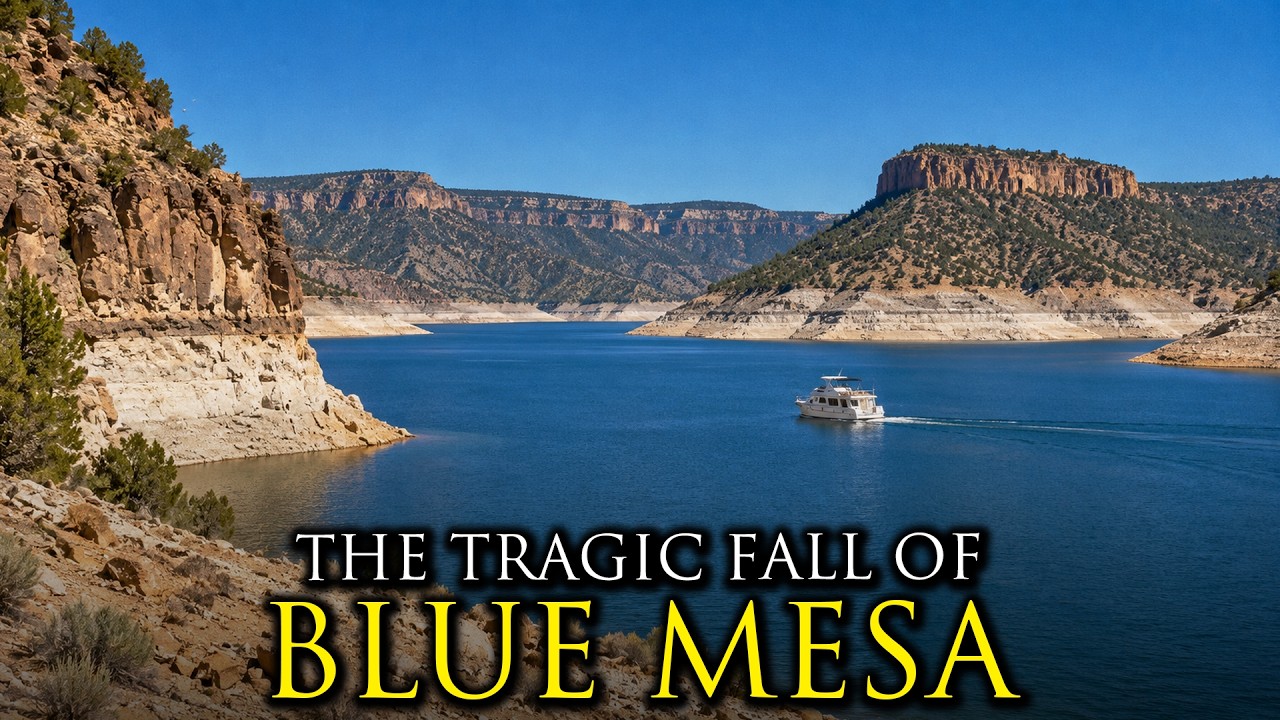
Because in 1922, a group of men sat around a table and divided a river using numbers that were wrong. A century later, that mistake carries the force of law. The lake was built on a promise, the promise was built on a lie, and now the lie is visible from space. A chalky white line runs along the dark volcanic rock above the waterline like a scar.
It marks where the surface of Blue Mesa used to be. Below it, the stone is stained pale by decades of mineral deposits. Above it, the rock is dark and untouched. The distance between the white line and the actual water keeps growing, sometimes thirty feet, sometimes sixty.
Locals call it the bathtub ring. It measures how much of the lake is already gone. Blue Mesa sits at roughly 7,500 feet in the upper Gunnison basin, surrounded by sage and volcanic mesas. The Gunnison River carved through this country for millions of years, cutting a canyon deep enough that sunlight reaches the bottom only a few hours a day.
This was Ute land for centuries. Bands of the Tabagui, whose name referred to the people of Sun Mountain, hunted and camped across the basin long before any European arrived. They understood the Gunnison River, its spring floods fed by snowmelt, its low late-summer flows, the ice that locked the canyon quiet every winter. When trappers and miners pushed into the area in the mid-1800s, they found a valley that was beautiful and brutally remote.
Small communities grew along the river, places like Iola, a tiny settlement near the confluence with a schoolhouse and a handful of ranching families, and Sapanero, a stop on the Denver and Rio Grande Railroad where the line crossed the Gunnison on a narrow bridge that made passengers grip the edge of their seats. These were not wealthy places. They were communities that lived along the water because the water was there. They had no way of knowing they were living at the bottom of a future lake.
The reason a lake was coming started seven hundred miles downstream, in a conference room with a catastrophic miscalculation. In 1922, representatives of seven western states gathered to divide the Colorado River. The negotiations were led by Herbert Hoover, then Secretary of Commerce. California was growing so fast that the other six states feared it would simply take everything unless a legal framework stopped it.
The result was the Colorado River Compact, signed at a ranch resort outside Santa Fe, New Mexico, in November 1922. Hoover’s team split the river into two basins at a point called Lee Ferry in northern Arizona. Each basin was allocated 7. 5 million acre-feet of water per year, 15 million total.
The math was based on flow measurements taken during the first two decades of the twentieth century, which showed an average annual flow of roughly 16 to 17 million acre-feet. The negotiators figured they had a generous margin of safety built in. Nobody at that table knew they were measuring the river during one of the wettest periods in at least 500 years. Tree-ring studies conducted decades later revealed that the long-term average flow of the Colorado River was closer to 12 or 13 million acre-feet per year.
The compact promised 15 million from a river that reliably produced around 12. The math was wrong by roughly 20 percent, and every dam, reservoir, irrigation canal, and legal obligation built on top of that compact inherited the error. For a long time, it didn’t matter. Wet years masked the shortfall.
The great reservoirs stored so much water that the system had a buffer measured in years. But the structural deficit was always there, like a crack in a foundation that doesn’t show until the ground shifts. This is the world that produced Blue Mesa Reservoir. The man who willed it into existence was a congressman from western Colorado named Wayne Aspinall.
Aspinall was patient, procedurally ruthless, and devoted to the idea that western Colorado’s rivers existed to serve western Colorado’s people. He served in Congress for twenty-four years and eventually became chairman of the House Interior and Insular Affairs Committee. He had a simple philosophy: use it or lose it. If Colorado didn’t build the dams and canals to put its compact share to work, the lower basin states, especially California, would consume every drop.
He pushed for years to authorize what became the Curecanti Unit, three dams on the Gunnison River stacked one below the other. Congress authorized the project as part of the Colorado River Storage Project Act of 1956, the same legislation that funded Glen Canyon Dam and Flaming Gorge Dam. Blue Mesa, the upstream giant, was the centerpiece. Construction began in the early 1960s.
The dam is an earthfill structure rising nearly 400 feet above the riverbed and stretching close to 800 feet across at its crest. When it closed in 1965, the Gunnison River had nowhere to go but up. The water crept over ranch roads, flooded creek bottoms, and swallowed fences and stone foundations an inch at a time. The families of Iola had already been relocated, bought out and moved to higher ground.
The old schoolhouse, the ranch buildings, and the railroad grades near Sapanero went under. An entire geography of memory was deliberately and permanently erased, not by a flood or a disaster, but by a plan and a legal document signed in Washington. The valley was replaced by a lake. For a time, the lake looked like a miracle.
By the late 1960s, Blue Mesa had become a shimmering inland sea of approximately 9,000 acres, stretching twenty miles through the sage-covered mesas. The Bureau of Reclamation stocked it with rainbow trout, brown trout, lake trout, and crucial to the recreation economy, kokanee salmon, landlocked sockeye whose fall spawning runs turned the reservoir into one of the premier cold-water fisheries in the mountain West. Marinas went in. Fishing guides built businesses.
In the fall, anglers drove from Denver, Kansas, and Texas. The Curecanti National Recreation Area attracted campers every summer, and recreation contributed tens of millions of dollars annually to the local economy. It felt permanent, like the landscape had always been this way. What nobody talked about much was the legal plumbing underneath it all.
Blue Mesa was not just a recreation lake. It was a storage unit in the Colorado River system. Water released from Blue Mesa flowed downstream into the Colorado River, toward Lake Powell, and ultimately toward the lower basin states. Colorado, as an upper basin state, had an obligation to ensure a certain volume of water crossed Lee Ferry every year.
Blue Mesa was part of the accounting. The system had a designed hierarchy, and Blue Mesa was not at the top of it. Lake Powell was. When drought came, the Bureau of Reclamation had a clear and unbending priority: keep Lake Powell alive.
The water to do it had to come from somewhere upstream. The drought that began around 2000 turned out to be the most severe sustained dry period in at least 1,200 years. Rising temperatures increased evaporation. A greater share of winter precipitation fell as rain instead of snow, running off immediately instead of sitting in the snowpack.
What snow did fall melted earlier and faster. Lake Powell plunged toward what the Bureau called deadpool, and the Bureau came looking for water upstream. In 2022, the Bureau of Reclamation announced emergency releases from upstream reservoirs to prop up Lake Powell. Blue Mesa would release an additional emergency volume, whether the communities that depended on it liked it or not.
For Gunnison County, the effect was like watching someone drain your savings account to pay a stranger’s debt. By the worst stretch of 2022, the reservoir had fallen to roughly a third of its designed capacity. Boat ramps sat high and dry, their concrete aprons ending in dirt. Entire arms of the reservoir ceased to exist as navigable water.
The marina at Lake Fork had to relocate its docks farther from the original shoreline, chasing the retreating surface. Then the ghosts appeared. As the water pulled back, the old landscape began to reemerge. Stone walls from ranch buildings in the Iola area.
Old fence posts standing in gray silt. The outlines of roads that hadn’t seen daylight since the Johnson administration. Remnants of the old railroad grade near Sapanero surfaced. People drove out and hiked across the exposed lake bed to see them, posting photographs with a mixture of fascination and grief.
The landscape that had been sacrificed for the reservoir was returning as the reservoir itself was sacrificed for something else. The kokanee salmon were devastated. As the reservoir shrank, the volume of suitable cold-water habitat collapsed, and the tributary streams where they had spawned were no longer connected at the right elevation or time. The numbers dropped to a painful fraction of what they had been.
Guides who had built careers on the fall run found fewer clients. The economics rippled outward through the small county economy. Nobody was starving, but the margin of prosperity that Blue Mesa had provided for decades was visibly thinning. The irony would have infuriated Aspinall.
His entire political career had been built on the principle that Colorado needed to claim its share before the lower basin states took it all. He got the dams built. He created the infrastructure that was supposed to guarantee Colorado’s future. And now that very infrastructure was being used as a piggy bank for the downstream states he’d spent decades fighting.
The drought did not create this crisis. The drought revealed it. Even if snow returned in biblical quantities, the structural problem would remain. The compact overallocated the river.
Seven states, at least thirty tribal nations with their own senior water rights, and major cities from Los Angeles to Denver all depend on a system that promises more water than the river reliably produces. The reservoirs were the buffer. When the buffer runs dry, somebody has to lose water, and the legal framework decides who. Colorado holds paper rights to water it hasn’t fully used, but it also has an obligation to keep delivering downstream.
When the system is short, the reservoirs inside Colorado’s borders get tapped to make up the difference. Through 2023, 2024, and 2025, the basin states and the federal government ground through agonizing rounds of talks about reducing consumption. California faced enormous pressure to cut its take. Arizona accepted significant cuts.
The upper basin states pushed back against bearing the burden when they had never fully used their allocation. Tribal water rights, ignored in 1922, added a layer of complexity. The federal government paid farmers to leave fields fallow and leave water in the rivers. None of it fixed the underlying arithmetic.
The river still produces less water than the legal framework promises, and climate projections suggest it will produce even less. Meanwhile, Blue Mesa waits. Some years bring better snowpack, and the reservoir recovers a partial measure of what it lost. The winter of 2022 to 2023 dumped heavy snow, and the spring runoff pushed the reservoir back up enough to give people hope, enough to reopen a boat ramp or two.
But one good year doesn’t erase a two-decade deficit. The trajectory, measured across decades, moves in one direction. The bathtub ring grows. The exposed lake bed hardens and cracks.
The old stone foundations near Iola sit in the open air, waiting either to be submerged again or to stay exposed for good. And nobody can say with confidence which it will be. Today, the Bureau of Reclamation updates Blue Mesa’s storage data daily. The number fluctuates with the season, but the long-term trend tells a story no single snowpack can rewrite.
On a September evening, the reservoir stretches out below Highway 50, smaller than it used to be, lower than the boat ramps were built for, but still that impossible deep blue of high-altitude water. There are still boats on a good day. Still anglers working the drop-offs for lake trout. Still families at the pullouts, standing on ground that was underwater when their parents were young.
The white ring glows faintly on the far canyon wall, patient and exact. Below it, the water. Above it, the dry dark rock.
And the distance between them growing wider season by season, a slow and public accounting of a promise made before the lake existed, before the dam was poured, before anyone alive today was born.
